RailPictures.Net Photo: CSXT 3408 CSX Transportation (CSXT) GE ES44AC at West of Mary Helen, Kentucky by Craig Williams
 
  Login · Sign Up 


Community Response Locomotive Details Location/Date of Photo
Views: 2,377     Favorited: 10
Since added on November 01, 2018

+ Add to Favorites

+ Subscribe

+ Add to Photo Album

+ Post a Photo Comment
     
» CSX Transportation (CSXT) (more..)
» GE ES44AC (more..)
» CSXT Merna Spur 
» West of Mary Helen, Kentucky, USA (more..)
» October 18, 2018
Locomotive No./Train ID Photographer
» CSXT 3408 (more..)
» CSXT C633-18 (more..)
» Craig Williams (more..)
» Contact Photographer · Photographer Profile 
Remarks & Notes 
The CSXT CV Sub runs 118 miles south out of Corbin, KY, to Pennington Gap, VA. Not alot runs out here normally except the Brice Limestone trains and a few coal trains that are loaded around the mines in the area. 
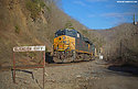
A C633 loading crew has the 1st cut of a coal train loaded at the Creech Mine. They are now pulling out to the CV main at Glidden to set that loaded cut to the main. Then they will grab the 2nd half of the empty train, off the siding, and shove back to Mary Helen to flood load the rest of the train. Old time railroading at its best in the heart of Kentucky Coal Basin. The mine at Mary Helen is operated by Lexington Coal Company who looks like maybe reopened this mine in 2017 after it being idle since 2012? The Mary Helen Coal Co. opened the Coalgood mines and company town in 1919. One thing that saved this cool old company store is that the post office was in it until 2004. Over 100 years of mining has gone here. What a cool place!
Photo Comments (0) 


 User Photo Albums Containing this Photo (1)+ Add to Album
Eastern Kentucky Railroads

Album created by member James Gentry
Album Views: 49,423
Shots of rail action in the Eastern Coalfields of Kentucky.
Add to Photo Album or Get Your Own Photo Album


EXIF Data for this photo: [What's this?]
- Hide Data -

  ApertureFNumber  f/2.8
  Make  DJI
  Model  FC330
  ExposureTime  1/800
  ISOSpeedRatings  100
  Flash  32
  FocalLength  361/100
  GPSLatitudeRef  N
  GPS.GPSLatitude  36° 48' 21.10"
  GPSLongitudeRef  W
  GPS.GPSLongitude  83° 16' 6.97"
  GPS.GPSAltitude  288.298

Photo Copyright © 2018 Craig Williams. All Rights Reserved. Photo Usage Policy
This website Copyright © 2002-2024. All Rights Reserved.
Do Not Sell My Personal Information