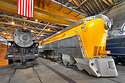
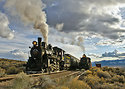
Steamscape: Gleason Creek. There are a number of spots on the active trackage of the Nevada Northern Railway Museum that photographers have tended to favor. This is my favorite, right here. Named for the Gleason Creek, which basically flows along most of the route of the NN's "Ore Line", this particular spot is perhaps a half mile southwest of the Keystone Wye at about MP 145.3. I like it so much because it features beautiful desert rock formations in the background, and in the winter, there is typically at least some snow here. The afternoon lighting is superb, and the geography on the west side of the creek offers a variety of elevated camera positions. There is also a nice rock cut that can be seen on the right side of the photo, which offers a very different angle on the train. Just behind the train, the fence-like structure that you see is the guard rail on US Highway 50, the Lincoln Highway. For those who may be concerned about the authenticity of a highway right next to the track, they should not be. Historic photos from the first half of the 20th century show that very same road, looking pretty much as it does now.
As attractive as this scene depicting Nevada Northern Consolidation #81, and the "Steptoe Flyer" consist may be, the scene just over the hill behind my back is equally unattractive. Less than 1,500 feet from where I shot this, lies a MASSIVE complex of open-pit copper mines, which were the reason for the existence of the original railroad. And while I've seen the tall "mountains" of mine tailings that tower over some of the natural hills and peaks nearby, I had no idea of the size of the big open hole in the ground just west of me, until I looked at it on Google Earth when I got home. And yes, those mines are still very much active today, as the demand for copper is sky-high with the proliferation of electronics in our modern lives.